“Give a man a fish, and you feed him for a day. Teach a man to fish and you feed him for a lifetime.” - Lao Tzu
At around noon on the 25th of April, Central Nepal was hit by the worst earthquake the small, mountainous country had ever seen. Leaving thousands dead and hundreds of thousands displaced, many without access to medical supplies or sanitized water, the Ghorka Earthquake as it would become known, uprooted not only cities and villages, but homes and families that had existed in the mountains for centuries. Hearing about the extent of the damage that Ghorka had inflicted, the best of the drone industry got together to make a real difference for the future of Nepal. Teaming up with with Humanitarian UAV Network “UAViators”, Swiss 3D Aerial Mapping organization, “Pix4D”, smartphone manufacturer “Smartisan” and Kathmandu University, DJI got to work on a plan, a plan that drew together some of the best and brightest of the UAV industry to give hope back to shattered communities.
The project brought together Kathmandu University students with high-tech resources and trained the local teams of the future to respond efficiently with relief efforts in disaster-prone areas. Kathmandu Flying Labs, a local innovation lab working with UAViators wanted Nepal to be the proving ground for a whole new way of effectively mapping and scanning damaged areas and improving efficiency in reacting to any further catastrophic natural disasters.
On September 20th, DJI’s Paul Moore and Randy Braun, Pix4D’s Kike Calvo and Krista Montgomery and UAViators’ Patrick Meier met up in Kathmandu to determine how they would first begin teaching the students the steps and knowledge necessary to use and understand the drones and equipment they would be using to conduct the mapping. Recently, drone use had been an issue in Nepal, with the Nepalese Civil Aviation Administration (CAA) being wary of allowing their deployment due to tourism, but with the assurances that DJI and our partners were there to teach, not merely film, they quickly got on board and became an integral part of the solution.
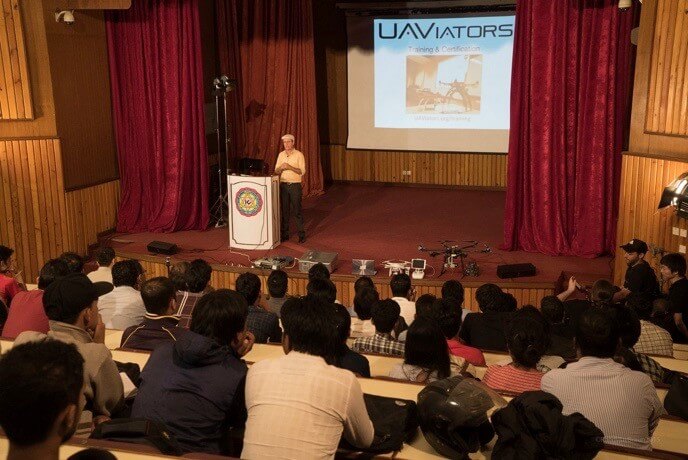
The first three days would be spent getting the students adjusted towards using the Phantom 3’s that were going to be used throughout the project. This meant teaching the fundamentals of drone usage, the key steps involved in aerial mapping, as well as knowledge and understanding of humanitarian relief efforts that are possible with drones. The students expressed a deep and passionate interest in, not only the possibilities and capabilities that drones presented, but the knowledge that these small, aerial vehicles could be used to save lives and make a genuine impact on destroyed communities.
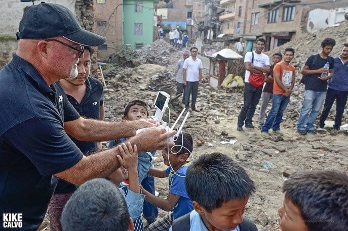
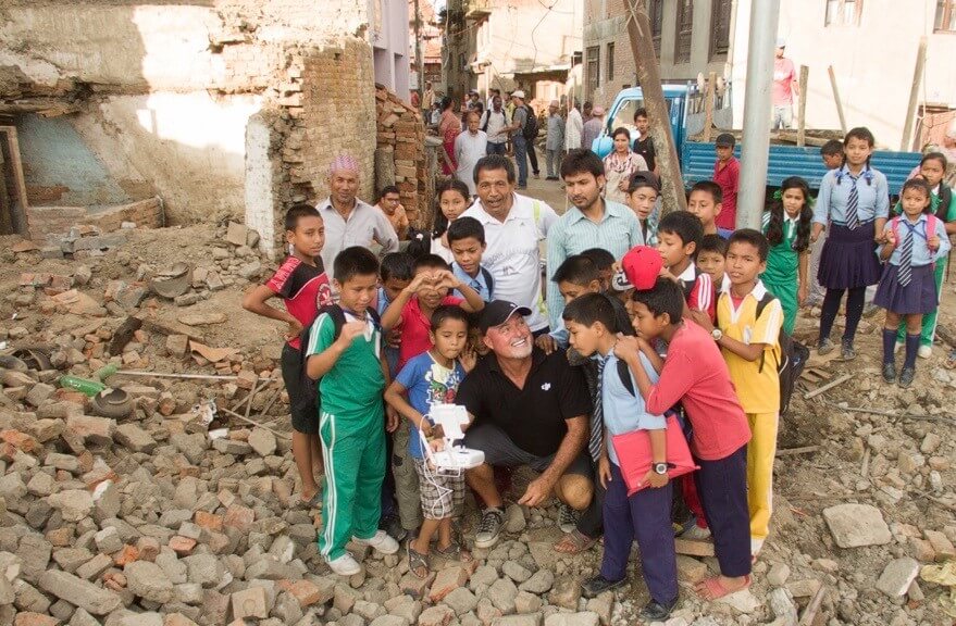
After those initial first introductions, the students were brought to the nearby village of Panga, which had suffered an incredible amount of devastation. In a single day, over 600 buildings in Panga had been utterly destroyed. DJI’s Paul Moore described the scene: “Before going to Nepal I’d had this idea of a country rich in history and architectural beauty, but when I arrived in Panga and stood right there, in the rubble, I was so incredibly shocked to see what had been lost that I was left speechless for a few minutes.”
Award-winning National Geographic Photographer, Kike Calvo, who was tasked with documenting the experience for Pix4D, reflected on his experience: “Everyone was busy setting up the Phantoms and finding the best spots for taking off, and I could not stop staring at this group of people, removing rubble from a pile, on what was a building before. It was incredibly inspiring to see all the people of the village out working together. We were there to show that drone technology is not only about creating beautiful imagery, its also about being able to empower local communities to address specific problems, and to help create a social awareness about the issues that need to be addressed around the world. It really brought home the reality of what we were here to do, using maps to bring back Nepal’s past and draw out it’s architectural future.”
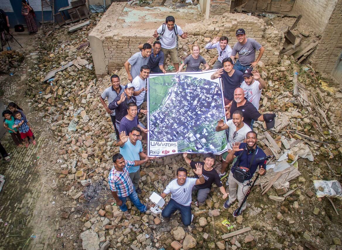
Using the Phantom 3, and with the Katmandu University students helping out every step of the way, most of the streets of the village were documented with video and still photos from above, and the entire town of Panga was faithfully recorded as an ortho-rectified map. Some sections werefirst made into a 3-D model, thenhigh-definition maps were printed into 2x3 meter canvases and hung on display in the town center. The villagers then began to place notes all over the map, identifying sources of fresh water, emergency shelters and escape routes. This experience marked the first time which the local Nepalese residents had seen their own village from above.
Throughout the whole experience, the team enjoyed the constant support and gratitude of the local townspeople, as well as the heartfelt appreciation of the 29 Katmandu University students who had not only contributed to the project’s success, but learned valuable aerial skills which would serve Nepal for years to come. “This was a large-scale collaboration that showed the willingness and eagerness of young professionals to become well versed in this technology of the future as well as a crucial part of its development” remarked Krista Montgomery of Pix4D, “we’re looking forward to see the young professionals involved in the training go on to use this knowledge in the fields of surveying, geomatics, and more. I think drones and photogrammetry will play a huge part in democratizing mapping, and this training just showed a small part of what will soon be possible as more and more professionals use UAVs and software like Pix4Dmapper.”
The students from Katmandu University consistently showed themselves to be incredibly able and fast learners, who, within a short amount of time were already suggesting new and interesting ways with which drones could be utilized, such the inspection of power lines, measuring landslides, or the gradual observation over time of Nepalese glaciers. Their dedication, pro-active attitude and clear commitment to the project and the bigger picture never wavered, even during the long and stressful shooting process.
On the third and final day, the team had processed the imagery gained from the field mapping, working in the computer labs at Katmandu University, with the whole group excited to see the sheer confidence with which the University students had begun to show using the Phantoms provided. In the past, Katmandu had had to build its own drone to measure glacial activity near Everest, now with the convenience of the DJI Phantom, this difficult process of creating their own drone could be negated.
Nepal had been a proving ground not only for drones and their application in tragedies, but an unforgettable experience to show what drones can do for the possibilities and hopes of the next generation of thinkers and makers, those to whom this technology will fall when the next boundaries will need to be pushed and the challenges of tomorrow will be brought forward to today.
Our special thanks goes out to all those who helped us make this project a reality: Katmandu University, the 29 students who took part, UAViators, Pix4D, Smartisan and the Nepalese government for their continued support and assistance.
Post-Quake: 3D Panga by Pix4D on Sketchfab
To see more of UAViators contributions to the Nepal project, check out: http://iRevolutions.org/2015/09/28/aerial-robotics-in-the-land-of-buddha
Kike Calvo’s new book “So You Want To Create Maps Using Drones?” which deals with the subject of aerial mapping in-detail, is now available on Amazon
Pix4D’s work in the mapping industry is well-documented at their website: https://pix4d.com


