Innovative Drones Help Find A Lost Plane
During World War II, Allied planes would fly what was known as the Snowball Route. US aircraft would hop across a chain of secret bases in Newfoundland, Greenland, and Iceland before arriving in the United Kingdom. Hundreds of bombers and fighters arrived to support Allied forces pushing back against a Nazi invasion, but along the way, a group of eight planes was lost in Greenland, driven out of the sky by a fierce snowstorm. They crash landed on a glacier, and over the years, became buried under thick ice.
That didn't sit well with Jim Salazar, a California businessman who helped put together a search team with the intent of finding what became known as the Lost Squadron. He and a colleague, Ken McBride, founded a non-profit called Arctic Hot Point solutions. The goal was to locate the missing planes. They also hoped to develop new techniques that could help located other wrecks, where the pilots bodies had never been recovered. The carried out this work under the banner of the Fallen American MIA Repatriation Foundation.
The key to finding the lost planes is ground penetrating radar that can look below the surface of the icey glacier and identify large metal objects. Initially the team pulled the radar on sleds, but it was slow, treacherous work. They had to watch out for crevasses that could swallow up people and equipment, and keep one eye out for hungry polar bears.
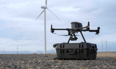
Over the last year, however, the team achieved a breakthrough with a new approach. They began using a modified DJI M600 drone to carry the radar. The drone could cover as much territory in a half hour flight as the ground team covered in a day. It was also far safer and more comfortable for the team to stay sheltered. Salazar and Mcbride were joined by Mario Carnevale and Myles Danforth of Hager GeoScience Inc. and Janis Kuze and Alexey Dobrovolskiy of SPH Engineering, developers of the UgCS software the team used on this mission.
When the drone detected an anomaly 300 feet below the surface, the team went on foot to confirm. They then dug into the ice using water from a hot pressure washer to tunnel down. When they pulled the probe back up, it was covered in a thick red liquid. While they were confused initially, experts informed them that this was likely a type of hydraulic fluid specific to the the P-38 warplane. The mission will continue next summer, when the search team will return and attempt to dig the plane up.
The use of drones to carry ground penetrating radar could have other important applications. A team of researchers from Bogota, Columbia recently showed off a design for a drone with ground penetrating radar that they hope can be used to search for landmines buried deep underground. “We believe that these two technologies will prove to be a vital tool in a host of applications,” said Salazar. “and we are excited to be a part of this.”Along with digging out the P-38, Salazar and his collaborators will continue the search for missing crew from a Coast guard crash., with the goal of finally bringing their bodies home.