
Your Everyday Commercial Drone
Your Everyday Commercial Drone
The Mavic 3 Enterprise Series redefines industry standards for small commercial drones. With a mechanical shutter, a 56× zoom camera, and an RTK module for centimeter-level precision, the Mavic 3E brings mapping and mission efficiency to new heights. A thermal version is available for firefighting, search and rescue, inspection, and night operations.
Compact and Portable
4/3 CMOS Wide Camera [1]
56× Hybrid Zoom
640 × 512 px Thermal Camera [2]
45-min Max Flight Time [3]
DJI O3 Enterprise Transmission
Centimeter-level Positioning with RTK [4]
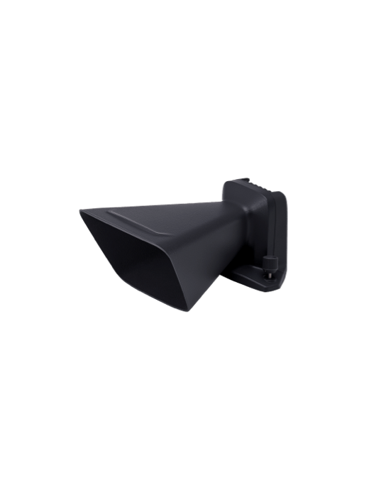
High-Volume Loudspeaker [4]
Streamlined and compact, Mavic 3 Enterprise Series can be carried in one hand and deployed at a moment's notice. Perfect for beginner and veteran pilots alike, it's built to perform on lengthy missions.

Wide
4/3 CMOS, 20MP, Mechanical Shutter
Tele
Equivalent Focal Length: 162mm, 12MP, 56× Hybrid Zoom

Wide
Equivalent Focal Length: 24mm, 48MP
Zoom
Equivalent Focal Length: 162mm, 12MP, 56× Hybrid Zoom
DFOV: 61°, Equivalent Focal Length: 40mm, Resolution 640 × 512
Quad-antenna O3 Enterprise Transmission enables more stable connections in a wide variety of complex environments.
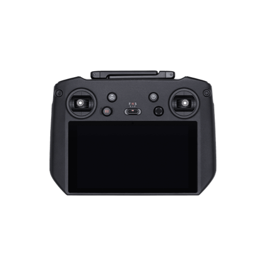
A portable remote controller with a 1,000-nit high-brightness screen for clear visibility in direct sunlight, a built-in microphone for clear communication, and 1.5-hour 65W fast charging.
Achieve centimeter-level accuracy with RTK and support for network RTK, custom network RTK services, and D-RTK 2 Mobile Station.
Broadcast your message from above, with support for text-to-speech, audio storage, and looping, to improve search and rescue efficiency.
D-RTK 2 Mobile Station is DJI’s upgraded high-precision GNSS receiver that supports all major global satellite navigation systems, providing real-time differential corrections that generate centimeter-level positioning data for improved relative accuracy.


Local Data Mode

One-Tap Clear All Device Data

AES-256 Video Transmission Encryption

Cloud API
PSDK is a unified interface that enables expansion of Mavic 3 Enterprise Series capabilities through third-party hardware.
Mobile SDK 5 simplifies the development of apps to control the Mavic 3 Enterprise Series. Mobile SDK 5 is fully open source and comes with production code samples of core DJI Pilot 2 modules.
With Pilot 2's built-in MQTT based protocols in DJI Cloud API, you can directly connect the Mavic 3 Enterprise Series to Third-Party cloud platforms without having to develop an App. Access the drone's hardware, video live-stream, and photo data.
For more information about product demo or trial, leave your contact information in the form below. You can also reach out to your local dealer for more information.


1. Available for Mavic 3E only.
2. DO NOT expose the thermal camera lenses to strong sources of energy such as the sun, lava, or a laser beam. Otherwise, the camera sensor may be burned leading to permanent damage.
3. Measured at 32.4 kph uniform speed at sea level in a windless environment. For reference only. Please pay attention to the DJI Pilot 2 App for return flight tips when actually flying.
4. Accessories sold separately.
5. At a GSD of 5 cm, with an 80% front overlap rate, a 60% side overlap rate, and a flight speed of 15 m/s.
6. Please do not fly in bad weather such as high wind (wind speeds 12m/s and above), snow, rain, lightning, fog, etc. Do not fly at altitudes above 6000 meters. Do not fly in an environment below -10° C (14° F) or above 40° C (104° F). Do not take off on moving surfaces (e.g., moving cars, boats). Do not fly in specular reflective areas such as water or snow to ensure proper operation of the visual positioning system, and fly in a well-lit environment when GNSS signals are weak. Low ambient light may cause the vision system to not work properly. Please pay attention to flight safety when flying near electromagnetic interference sources. Common sources of electromagnetic interference include high-voltage power lines, high-voltage transmission stations, radar stations, cell phone base stations, broadcast towers, Wi-Fi hotspots, routers, Bluetooth devices, etc.
7. Supported in manual flight mode only. Caution is recommended when flying in hazardous environments.
8. Currently only available when purchasing DJI Mavic 3 Enterprise Series.