Intuitive interface
DJI emphasises the principle of user friendliness in all designs, the ground station offers 3D graphic interface, a breakthrough from traditional UAV system with ease of installation, less complexity and ease of operation in comparison to others in the market. DJI ground station control can save time, improve operation efficiency, ease mission planning supporting flexible and intelligent control for any mission.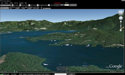
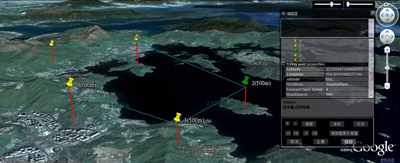
Google 3D maps
DJI Ground Station designed around intuitive Google 3D map offering GIS data. Pilot can operate and plan flight routes anywhere, use PC mouse to zoom in/out of 3D Maps which can be downloaded to PC and used elsewhere in offline mode.
Accurate flight control algorithms
The entire ground control system combines GPS 6DOF inertial measurement unit, magnetometer, and pressure altimeter sensors to optimize robustness of algorithms and robotic control logics. Ground control system utilizes advanced GPS/INS proprietary algorithm technology in the entire design. Even in adverse conditions, high vibration and high demand environments, the aircraft maintains flight stability accurately to ensure mission success rate.
Real-time flight monitoring
In addition to the aircraft location, heading and altitude, our ground station also provides other flight data such as attitude, air speed, vertical speed, throttle and pitch percentage and servo voltage at all times.
Auto return home
Ground Station equipped with intelligent adaptive system. During abnormal signal loss , the system will adjust to environment to activate failsafe appropriately. The aircraft will implement and complete the default route mission automatically, even when datalink signal is lost.
When user is in manual mode, the aircraft will hover when RC signal lost. But after 10S, if the signal doesn’t come back, the aircraft will find the take-off point precisely and return using the safest route and height . Then the aircraft will hover over the take-off point automatically. This function offers the intelligent security protection for user’s expensive aerial equipment. In addition, the user can always click the return button, the system will interrupt the current mission immediately to order to return the aircraft to back the take off point .

Keyboard/Joystick Mode
Operator can either use keyboard or joystick with ground station system to control the aircraft movements and attitude via DJI data link. Manual mode can be applied when out of radio (transmitter) signal range by using either keyboard or joystick for control. This provision/feature allows control when the radio (transmitter) stops working after the mission has started.
Click and go flight
Click on any point on a 3D map, the aircraft can achieve the coordinates point automatically, particularly useful when some routes cannot be set in advance. Flight altitude and flight speed can also be adjusted rapidly and accurately according to the change of data and waypoints when the user has to change the target and flight mission.
Beyond Visual Range (BVR) automatic flight
Beyond Visual Range (BVR) of Ground Stations System designed for high-end commercial and industrial automatic flight that requires a reliable long-range wireless communication device (Data Link) and ground station control system (GCS). The flight route, default action of photographs, and airdrop can be planned in advance on the ground station control software.
Auto takeoff and landing
Waypoint controller advance development offers automatic take off and landing feature which can be applied using either by radio transmitter or ground station keyboard. Take off and landing (ascending and descending) speed is 0.2 to 0.5 meters per second.Customizable waypoints
Users can carry out special settings, such as height, latitude and longitude, flight speed, the nose toward, the turning patterns and residence time etc. User can batch for all destinations, by setting once if required.
6 preset route templates
Ground Station provides 6 types of pre-set route templates which are default settings that can assist in completing a mission quickly, in a designated area with set height. The size of coordinates for the mission area, the number of waypoints in the region, the waypoint properties, etc. can be customized. Those templates can be especially applied for vertical photography, precise mapping, spraying agriculture and other industries.
3 waypoint turning mode options
There are 3 different fight routing planning modes: fixed-point turn mode, coordinated turn mode and adaptive coordinated turn mode.
Fixed-point Mode: Aircraft flies to the first fixed point accurately, stays at the fixed point and then flies to the next fixed point . The fixed points and the length of each stay also can be set in advance. Coordinated turning mode: The route of aircraft is calculated with turning speed and turning angle. The aircraft would fly from one point to another point without stopping. Adaptive coordinated turning mode: It is almost the same performance with Coordinated Turning mode. But the flight routine will be more accurately detailed with a planned flight routine in this mode.


